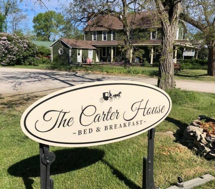
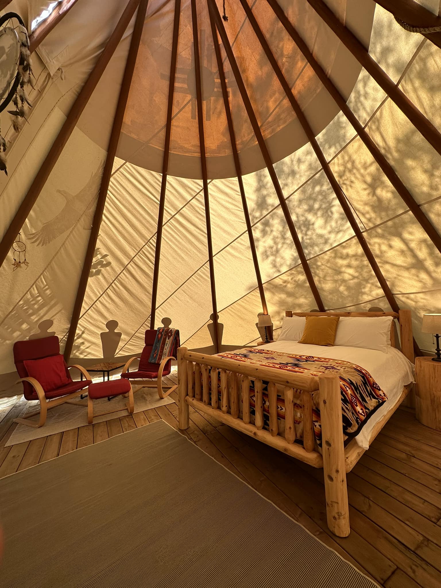
The Carter House in Kagawong, is a 126-year-old home converted into luxury accommodations, offering a wonderful bed and breakfast experience in a comfortable and relaxed atmosphere. The Carter House and Manitoulin Teepees are both situated steps from the captivation Bridal Veil Falls in Kagawong, Ontario. Manitoulin Teepees offer a unique lodging experience with luxury bedding, a communal kitchen, a shower house, bbqs, fire pit and more.
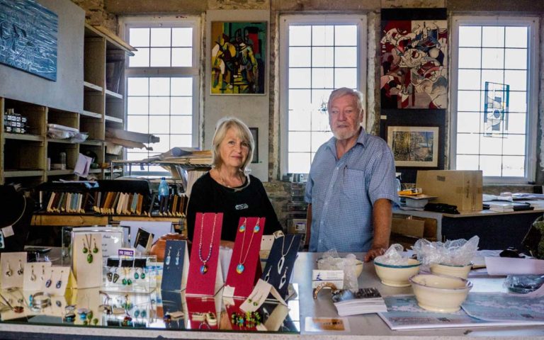
Perivale Gallery About Perivale Gallery Stunning art, discerningly selected and impeccably presented. These are the reasons Perivale Gallery is the premier
Little School House Museum – Informs about the community’s early fishing days through displays and artifacts and features the Island’s only remaining one-room school that has been preserved intact.
Ferry Dock – Besides being the loading and unloading point for the Chi-Cheemaun (which makes four return trips a day during the tourist season and two round trips daily during spring and fall), the ferry dock is a nice place to relax by the port.
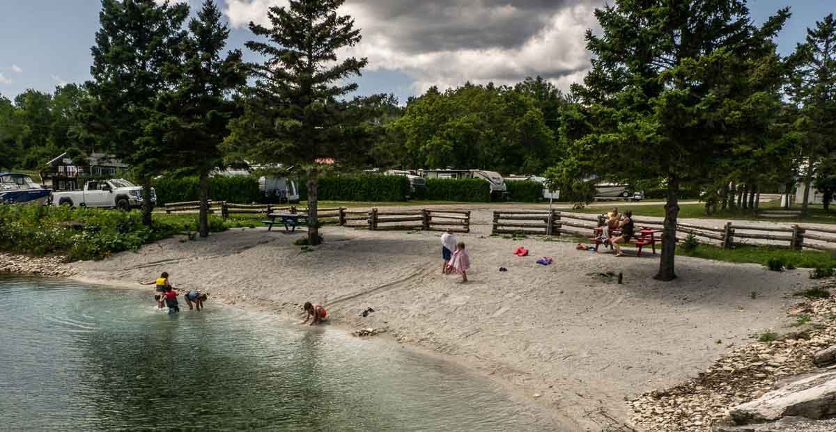
John Budd Memorial Park – A pleasant park with a nearby swimming beach appropriate for children.
Tehkummah
Blue Jay Creek Fish Culture Station – Operated by the Ministry of Natural Resources and Forestry, the station rears young lake trout for release in the waters of Manitoulin and the North Shore.
Fairview United Church – Built as a Methodist Church in 1897, this wood-frame church is surrounded by the gravestones of early members of the community.
Michael’s Bay Municipal Park – Located off the Government Road southwest of Tehkummah village, the park is ideal for picnics, swimming and fishing. The Manitou River and Blue Jay Creek both flow into Michael’s Bay.
Wiikwemkoong Unceded Territory
Wikwemikong Health Centre – Uniquely combining the science of Western medicine with traditional healing methods, the health centre is also worth a visit if only for its splendid design. The nearby Hub centre provides children’s services: nursery school, day care, toy library and resource centre.
The Historic Ruins – Large dormitory for Jesuit clergy that burned in the early 1950s located beside Holy Cross Mission Church. A perimeter of solid stone walls, two feet thick and three stories high (minus the roof), are all that remain of the building. Often a venue for Debajemjig storytellers summer offerings.
Bebamikawe Memorial Trail – Manitoulin’s newest trail and outdoor fitness park is located at Wikwemikong. Trailhead is at the end of Beach Road in Wikwemikong. The trail is 14 km of easy to intermediate trails, spectacular lookouts and educational signage. The Outdoor Fitness Park section of the trail is a double track, granular surfaced trail with five fitness stations equipped with outdoor fitness equipment so that trail users can take advantage of resistance training in a scenic natural environment. For information about the trail, contact (705) 859-3477.
Manitowaning
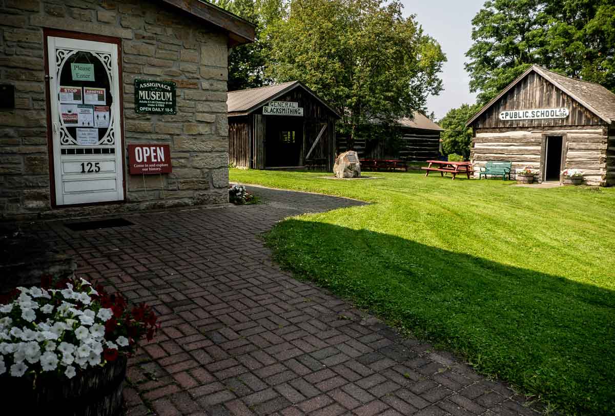
Assiginack Museum – Originally built as a lock-up in the 1850s, the museum contains a range of artifacts from the lives of early settlers in the area and is home to an impressive and expanding collection of antique glassware, porcelain and pottery. The museum grounds feature a schoolhouse, blacksmith shop and barn.
St. Paul’s Anglican Church – The oldest Anglican parish church in Northern Ontario was consecrated in 1849 and still stands serenely on the edge of the downtown, overlooking the expansive waters of Manitowaning Bay.
S.S. Norisle Heritage Park – Located at the Manitowaning waterfront. Home to a nineteenth century grist mill and the Burns Wharf Theatre building. Park includes docks, boat launch, change rooms and a great sand beach. Resting in permanent dockage is the S.S. Norisle, the last passenger steamship to be built in Canada after WWII. Go to www.norisle.com. Lighthouse – Located behind St. Paul’s Church and overlooking Manitowaning Bay, this operational lighthouse was built in 1885.
De-ba-jeh-mu-jig Creation Centre – Home of De-ba-jeh-mu-jig storytellers and the Kathleen Reynolds Mastin Gallery, in downtown Manitowaning. The theatre has taken over the old Mastin’s Store and amplified it to the tune of 14,000 square feet of space dedicated to theatre (and often other visual arts). Besides a massive black box rehearsal studio with a sprung floor, the two-level complex includes a carpentry shop, a costume shop, space for an actors’ green room and a great deal more. It’s well worth a visit. There are continuous activities there and usually an art installation in the Kathleen Reynolds Mastin Gallery. The old stone-fronted Mastin’s store provides the entrance. You can call (705)859-2204 or consult www.debaj.ca for more information, or just come in.
Sheguiandah
The Centennial Museum of Sheguiandah – The museum projects the life and times of the pioneers who settled here after the Manitoulin Treaty of 1862. Also displayed are artifacts from the prehistoric quarry, as well as the wreckage of a mail plane which was associated with President Roosevelt’s 1943 wartime visit to the area. Each summer the museum curator presents a busy agenda of art exhibitions, workshops and lectures. New installation is an interactive interpretive centre featuring the 9,500 year history of human activities in the community. A replica mill complete with a water wheel, is a feature on Bass Creek.
Hiking And Walks – An available tour map tells the story of nineteenth century Sheguiandah. Also, there are maps to guide you through village landmarks.
Fish Viewing Platform – Spring and fall, depending on the fish species, there is a platform especially available at Bass Creek from where to watch fish fighting their way up river to spawn. This is the joint effort of the Little Current Fish and Game Club and Manitoulin Streams.
Providence Bay
Manitoulin District Cenotaph And Memorial Gardens – Four distinct monuments; the Manitoulin District Cenotaph, the Merchant Marines Memorial, the Youth in Partnership with Veterans Memorial and the Women’s Memorial stand in this tranquil memorial garden located on Hwy 551/542 between Mindemoya and Providence Bay/Spring Bay. These monuments serve to remind us of the contributions and sacrifices made for the causes of peace and freedom by the men and women of Manitoulin during the twentieth century. The Cenotaph’s flags are those of Canada’s Second World War allies.
Discovery Centre – Located at the foot of the boardwalk just off the downtown. Snack bar and change rooms, the building houses an interpretive centre, which has a fascinating mixture of biological, historical and fossil displays, as well as a snack bar, ice cream parlour and washrooms.
Boardwalk – Spanning the Mindemoya River and running for a considerable length of the beach, this wheelchair-accessible boardwalk is worth a stroll.
Town Square – A new and colourful downtown focus for this town.
Mindemoya
Pioneer Park – Access Pioneer Park off Hwy 551 through a covered footbridge and visit the reconstructed pioneer log home, barn and hiking trails.
St. Francis Of Assisi Anglican Church – Built in 1933 of local stone in the ancient Norman style of early European churches. The church contains a number of interesting and rare artifacts.
Little Current
Heritage Swing Bridge – Constructed in 1913 for rail traffic only, the bridge rested in the open position to allow for the frequent passage of coal freighters through the North Channel. Today the railway is gone, and the 980 tonne bridge provides a link for automobile traffic between Manitoulin and the mainland, excepting 15 minutes on the hour, when it now swings for the Channel’s plentiful cruise boat traffic. The unique swing bridge has been designated an Ontario Heritage Bridge.
Manitoulin Welcome Centre – The first building on your right after crossing the bridge onto Manitoulin, this aptly-situated building is home to the Island’s best selection of information on what to see and where to stay during your visit.
Low Island And Sisson Park – Within walking distance of downtown, Low Island is home to Little Current’s best beach as well as a walking trail, playground, picnic area, change rooms, softball, volleyball and soccer grounds, skateboard park, a splash pad, a pump track for bikers and vie de parcours-style workout equipment.
Farmers’ Market – Find the market downtown on Water St. first thing Saturday morning.
McLean’s Mountain Lookout – Located just outside Little Current, the lookout on McLean’s Mountain provides one of the most spectacular views of the North and Wabuno Channels with the LaCloche Mountains on the horizon. The lookout includes picnic tables, barbecues and washrooms.
Aundeck Omni Kaning
Four Directions Complex – State of the art community centre, gym and library in the heart of the village
Birch Island
St. Gabriel Lalemant Roman Catholic Church – This beautiful church was built in 1940 of area stone and cedar.
Dreamer’s Rock – Accessible only with permission, this is a place where youth would come and dream of their destiny following a fasting time.
Roosevelt Monument – The monument commemorating U.S. President F.D.Roosevelt’s wartime (1943) fishing trip to nearby McGregor Bay is at the main intersection of Birch Island.
M’Chigeeng
Ojibwe Cultural Foundation – A mixture of gallery (displaying the work of local artists who work in a variety of media), educational, resource and meeting space. The Foundation also includes a traditional healing lodge, elders room and gift shop.
Lillian’s Museum – A wonderful permanent collection of First Nation art and crafts, especially porcupine quill work, augmented by education videos on aspects of First Nation culture. It features a unique quill box museum.
Immaculate Conception Church – An architecturally interesting Roman Catholic Church which incorporates elements of native tradition in both design and content.
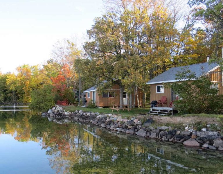
Kagawong
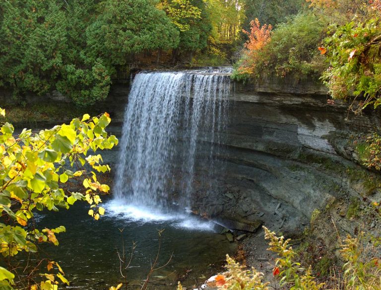
Bridal Veil Falls – The falls and river gorge are one of Manitoulin’s premier attractions. For the safest parking and most convenient access to both the falls and the trail system, park at the Kagawong Park Centre in lower Kagawong or near the river mouth in the vicinity of the Old Mill.
Vendors Market – A very busy market, every Wednesday 10 am to 3 pm during July and August, across from the Old Mill Heritage Centre.
The Billings Connections Trail – 32 heritage plaques and seven public sculptures located throughout the township, including on the river systems trails and in the hamlet of Kagawong. The plaques and sculptures are the result of a Canada 150mCelebration project. They provide information on township history and speak to the theme of municipal/community participation in Truth and Reconciliation.
Anglican Church – St. John the Evangelist Anglican Church, also known as the “Sailors” or “Boat” church is on the Kagawong waterfront, and features a pulpit fashioned from the bow of a pleasure craft wrecked off Maple Point with tragic loss of life.
Old Mill Heritage Centre – Located in the Old Mill (former pulp mill) building on the waterfront in Kagawong. The museum features local history and hosts special annual exhibits. The post office is an original structure, and features artifacts and information relating to early communication and transportation on Manitoulin Island. Featured in this building is also the home of Edwards Art Studios.
Beaches – The Kagawong beach is located in the heart of the village and is a wonderful kid-friendly sand beach. Another more expansive beach, Maple Ridge Sandy Beach, is approximately 2km around the bay from the village.
Old Church On The Hill – A gem of an entertainment centre located in a former church building that is the oldest structure in the municipality.
Gore Bay Street Market – Every Friday, from 9 am to 1 pm daily. July and August, the main street becomes a busy pedestrian-only street market.
Gore Bay Boardwalk – An interesting stroll through and across the very bottom of Gore Bay. The interesting boardwalk leaves from Smith Park (an open field waterfront recreation area) adjacent to a basketball court/skateboard park. Walk the other way and you’ll find the tennis courts.
Noble Trail – Begins at Bay and Water streets intersection, climbs the scenic East Bluff to park lookout.
Gore Bay Museum – High above the downtown and adjacent to the courthouse complex. Unique exhibits and a busy gallery that anually features local artists. An extension of the museum is on the waterfront beside the boat harbour; the Harbour Gallery features artists, gallery space in a superb setting.
Harold Noble Memorial Park – Up on the East Bluff, this park and picnic area offers a panoramic view of the harbour and surrounding countryside.
Harbour Centre Gallery – At west end of waterfront. The Harbour Centre Gallery is occupied by many local artisans whose work if for sale in their shops. William Purvis Marine Museum upstairs.
Gordon/Barrie Island
Janet Head Lighthouse – Located at Janet Head at the end of Lighthouse Road, this Georgian-style lighthouse was built in 1879 and contains a fascinating history of maritime life, local development, and tragedy. Visit for a guided tour available a few afternoons each week in July and August.
Manitoulin Golf – On Golf Course Rd. off Highway 542. Nine scenic holes, club and cart rentals. Restaurant and bar.
Gore Bay-Manitoulin Airport – Following the Second World War, the Federal Department of Transport decided to establish an airport on Manitoulin to provide radio and weather information and an emergency landing centre. Since its completion in 1947, the airport has remained a vital asset for the area.
Beaches – Enjoy both of Gordon’s sandy beaches located at Tobacco Lake and Julia Bay. Use the children’s area at Tobacco Lake or practice your diving on the raft at Julia Bay. Visit the Salmon Bay Park on Goosecap Crescent on Barrie Island for a peaceful picnic spot overlooking Lake Huron. While you’re there, use the nearby boat launch to take a tour of the waters – the same can be done close to the Julia Bay beach.
Sheshegwaning
This proud community features Nimkee’s Trail and the Nishan Lodge.
Zhiibaahaasing First Nation
See the world’s largest Peace Pipe, Dream Catcher and Pow Wow Drum located in the center of the community in the park, all welcome.
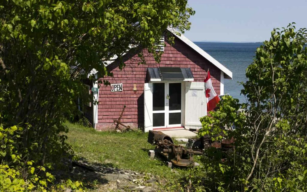
The Meldrum Bay Net Shed Museum. Expositor file photo.
Meldrum Bay
Net Shed Museum – Located in a building once used by fisherman to repair and store their nets, the museum is a tribute to the area’s marine heritage.
St. Andrew’s United Church and Community Hall – A well-kept church which has served the area for over 70 years is flanked by the nearby hall, site of numerous local events.
Manitoulin has many hiking trails which take anywhere from a couple of hours to a full day, requiring various degrees of fitness. For the casual walker, there are nature trails and boardwalks in and around many of the towns. Brief descriptions follow.
Gordon’s Park
On Hwy 6, just north of Hwy 542, this private park offers a nature interpretive centre with three complimentary hiking trails through five different eco systems, (wetland, forest, meadow, pond, escarpment). The Interpretive Centre features mounted animal displays of bears, wolves, hawks and owls plus interpretive information on mushrooms, fossils, edible wilds, astronomy, birds, trees, wildflowers and animals. Picnic area, pool, mini putt, camping, tipi tenting, B&B and store. Observation deck, bird blind, Dark Sky Sanctuary and astronomy observatory. www.gordonspark.com
McLean’s Park This verdant 100-acre park is located on New England Road, a sideroad off Hwy 6 mid-way between Manitowaning and South Baymouth. The park, about 3km along the New England Rd. features hiking trails based on ancient logging paths. Hardwood bush with some huge trees. The walk takes about 1.5 hours.
Cup and Saucer – Michigiwadinong Trails
Twenty km west of Little Current, with ample parking and trailhead off Highway 540, 3km past the Bidwell Road corner, is the well known Cup and Saucer trail. With its dramatic 70 metre cliffs and breathtaking views, up to 12km of hiking trails, and a 2km adventure trail, it is one of the most popular trails in Ontario. Anywhere from 1.5 to 4 hours. Spectacular views over both the North Channel and Lake Manitou.
Bridal Veil Falls
The Bridal Veil Falls trail system is located in Kagawong. Although there is access to the trail system at Bridal Veil Falls, which is adjacent to Hwy 540, there are much safer and roomier parking options in the lower hamlet of Kagawong, including at the Park Centre and in the vicinity of the river mouth as well as next to Dig and Doug’s Cedar Furniture. Park in lower Kagawong and enjoy the river trail system/falls on foot – you get the best of both worlds! The lower village includes other points of interest, and both the upper and lower village have unique shops. Note that the Bridal Veil Falls trail system is also part of the new Billings Connections Trail and includes access to several of the new public sculptures and heritage plaques installed as part of the Billings Canada 150 project.
Sheshegwaning – Nimkee’s Hiking Trail
North of Silver Water, off Hwy 540, the Sheshegwaning First Nation is developing a 20km trail, which can be enjoyed in several sections, some offering wonderful views of the North Channel. There are facilities for camping and picnicking. Trail maps are available at the Band Office or at the Gas/Convenience store at the trailhead. Allow 3 to 6 hours.
Misery Bay
Misery Bay Provincial Nature Reserve is a 860 hectare provincial park on the south shore of Manitoulin Island, a 10 minute drive west of Evansville. There is a trail network of eight trails totaling approximately 16 km (one way) and ranging in length from 0.2 km to 4.8 km (one way). The trails feature mixed woodland, old beach ridges, and rare alvars. There is a visitor centre/ interpretive centre to educate the public about this unique area. There is an easy loop of 4.1km from the visitor centre consisting of the Lakeshore and Wolf Den Trails. For more information visit www.manitoulin.com/misery-bay
Noble Nature Trail
The Noble Nature Trail is an easy to moderate trail that offers a 1.1km stroll east from its starting point at the intersection of Water and Bay Streets on the Gore Bay shoreline up to and along the East Bluff overlooking Gore Bay and the town. The Noble Nature Trail ends at the Harold Noble Memorial Park which offers a high vantage point that provides outstanding panoramic opportunities for that perfect photo of the Port of Gore Bay and its busy harbourfront.
Gore Bay Boardwalk Trail
The Boardwalk Trail follows the town’s waterfront and connects with the Noble Nature Trail. It travels 1.2km along the shoreline west to Fish Point Park, where the Harbour Centre Gallery and Split Rail Brewery are in the neighbourhood. The Boardwalk Trail offers an easy and accessible route along the length of the town’s waterfront will bring you to the newly constructed breakwall, providing an opportunity to get further out into the bay. Picnic areas are available along this trail as is direct access to the many downtown businesses and services.
Heaven’s Gate Trail
This approx 50km trail runs from the Willisville turn-off on Hwy 6 through to Fort Lacloche on the Sagamok First Nation, south of Massey. The multi-day hike runs through the magnificent Lacloche Mountains with beautiful views of the North Channel and surrounding lakes. However it is not well marked or maintained and only recommended for very skilled hikers. Guided hiking and canoeing tours of the area, with a Native theme, are available from “Trails of The Eagle Clan,” 705-865-2526, or email mowl@vianet.ca
Wagg’s Wood
Right off one of Mindemoya’s main streets, Hwy 542, Wagg’s Woods is located almost directly across the street from the municipal office and library building. Features maple, basswood, birch and ash. Moss climbs the cliffs which are part of the Niagara Escarpment. Watch for 15 different species of fern. Allow 1 hour.
Bowerman trails in South Baymouth
While you’re waiting for the Chi-Cheemaun ferry, or after you disembark, this trail is a great diversion. Access points are off the small boat harbour parking lot and across from the boat launch (south of the ferry terminal building) and also off Green Street in the same area. The trails take you up limestone steps, through the bush and offer Lake Huron views. Allow 1 hour.
Bebamikawe Memorial Trail
Located at the end of Beach Road in Wiikwemkoong, this trail is 14 km of easy to intermediate trails, spectacular lookouts and educational signage. The Outdoor Fitness Park section of the trail is a double track, granular surfaced trail with five fitness stations equipped with outdoor fitness equipment so that trail users can take advantage of resistance training in a scenic natural environment. Call (705) 859-3477 for more information.
Point Grondine Park
A First Nation-owned and operated recreational park, Point Grondine has over 7,000 hectares of scenic natural wilderness landscape, old growth pine forest, stunning river vistas and eight interior lakes to explore. The trailhead is ideally situated off Killarney Highway 637 nestled between the Killarney and French River Provincial Parks; it is in the northern terminus of the Georgian Bay Coast Trail, a sustainable world-class hiking trail in the spectacular landscape of the UNESCO Georgian Bay Biosphere Reserve. The park is accessible through mandatory park permits that can be purchased online at www.GrondinePark.com or by calling 1 (705) 859-3477.
The Little Current Recreational Walking Trail
The trail is a 12 km path (approximately 2 to 4 hours) that includes minimal elevation changes, a compact surface, trail lighting on most sections, benches and directional signage. This beautiful trail loops around the entire town of Little Current and includes a picturesque stretch of roughly five kilometers that follows the North Channel, including along the town’s unique downtown waterfront. Along this stretch, you will find a series of mounted historic plaques describing the town’s rich marine heritage. Visit Low Island, at the western end of the downtown Water Street as the trail circles the perimeter of the town’s waterfront park (1 km) where, in addition to several of the descriptive plaques, you can enjoy a vie de parkours-style workout on the sets of workout equipment provided there in addition to playground equipment for children, a beautiful sand beach, soccer and baseball fields, shaded pavilions, washroom facilities and a water bottle filler station.
A favourite section of the trail can begin (or end) at Low Island Park with a park loop and then along the waterfront to the Welcome Centre and the swing bridge, and then return along the same route. You can also begin at the Welcome Centre where there is ample parking. The return trip is 3 km.
The Lewis Twin Peaks Hiking Trail
This trail is in Sheguiandah and is accessible from the west side of Hwy 6, just across from Paradise Motel. Approximately 2km in length and a relatively easy hike, the trail nevertheless provides two quite spectacular views of Bass Lake and the North Channel. The lookouts are on Quartzite outcrops. Allow 1 to 1.5 hours.
Manitoulin is chock full of beaches both on the ‘big water’ Lake Huron side or in the plethora of inland lakes that dot the countryside. Here are just a few to sample on your Manitoulin holiday.
Providence Bay
The horseshoe crescent of golden sand beach in Providence Bay on the south coast is one of the Island’s top natural attractions, rated the “best” and the “longest” in Northern Ontario, stretching as far as the eye can see to the east and west of the wide bay. In the hot summer months, brightly coloured umbrellas shade the prostrate bodies that have travelled from near and far just to collapse here in the warm embrace of the sands, a kind of communal ritual that involves exhaling and sighing deeply upon arrival.
A family gathers round a blanket and a picnic basket, little kids squeal in wild abandon as they run in and out of the shallow waves, a solitary walker and dog amble the length of the curving arc of the ancient strand. One can imagine similar lakeside scenes when hundreds of Odawa lived and fished here in the 1600s, naming it G’Chiaazhwiyiing, or Sand Beach in English, according to historian Shelley Pearen, or Mindimoiesibing, Old Woman River.
A beachgoer is only a few steps from any of the village’s accommodations and places to eat.
At the beach, the Interpretive Centre hosts Huron Island Time, serving roti, patties and over 20 flavours of Farquhar’s ice cream among local art, clothing and gifts. Throughout the summer, their Sunset Music Series on the boardwalk presents local musicians and talented guests versed in country, folk, jazz and ‘50s and ‘60s rock. Check them out on Facebook.
A sliver of the famous beach at Providence Bay.
The view from here is magnificent: the immensity of sky and water stretching toward the seemingly infinite horizon is breathtaking. On the far left shore can be spotted the red roof of the marina, tiny from this perspective, and, still far in the distance, the beginnings of the beach on the east side and the mouth of the Mindemoya River where it joins Lake Huron.
On the right, or west, side of the bay, the beach goes on and on until it is but a tiny speck at the tip of Simcoe Point.
The beach is diverse: at this end, it’s sandy and a little more secluded; returning to the centre of the horseshoe beach, this is where the action is. The equipment in the generously outfitted playground gives kids a good workout; just behind is a parking area and a shady little park with picnic tables; here also is the Interpretive Centre, with washrooms. The village centre and its amenities are just a block away.
It’s heavenly down on the beach—the sand and water, sun and sky shimmering like a mirage, like a dream of a perfect summer’s day.
Lake Mindemoya
In Central Manitoulin, Lake Mindemoya’s long history as a vacation destination may be appreciated on a tour around the lake, a drive or bicycle ride on the little roads that contour the water on the east and west sides.
Lined on the eastern shore with old-time rental operations, a golf course, cottages and homes fronted by docks with deckchairs, this side of the lake has the quiet air of a well-loved, long established community.
There are several spots along here to swim, launch a boat and have a picnic. Driving or biking south on Hwy 551 toward the town of Mindemoya, turn right on Hill Road, down to the evocatively-named Ketchankookem Trail at the waterfront.
Pleasant grassy park areas back the beaches around the lake, strips of fine sand that serve as personal welcome mats into the nice-and-warm shallow waters ahead. Young and old picnic at tables and on blankets, launch a boat, take a dip or just hang out, gazing across the water to Treasure Island, the storied isle of legends.
Treasure Island, or Mindemoya Island, is seen from almost anywhere around the lake; the shape resembles a prostrate human form with arms resting outstretched over the water. An old Anishinaabe legend tells of Nanabush, the infamous Trickster, who stumbled while carrying his grandmother over his shoulder, causing her to fly through the air to the middle of the lake where she landed on her hands and knees. Mindemoya (Mndimooyenh), the old woman of the lake, remains here ever since.
Still on Ketchankookem Trail, the road will join up with Lakeshore Road, another lovely lane to wander, and Highways 542/551; follow 551 along the south shore of the lake, stopping at still another small, quiet picnic area then proceeding west until the turn on the right to Monument Road.
Monument Road is a Bike Route—as are all the roads around the lake—and a little piece of rural heaven: split rail fences sprout among flat limestone pavements, a few homes and cottages peep through the forest cover, cyclists and walkers, children and dogs meander as the road winds gently around the west side of Lake Mindemoya and another public beach, with picnic tables on a strip of lawn, benches, parking and portable toilets. A few hundred yards up the beach is a new boat launch.
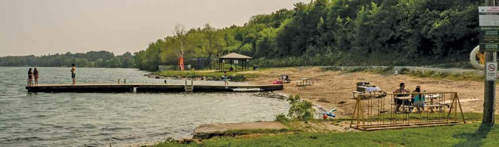
Low Island Park
At the far northeast tip of the town of Little Current in the Town of Northeastern Manitoulin and the Islands (NEMI), overlooking the North Channel of Lake Huron and the LaCloche mountains on the far shore, a great summer getaway awaits.
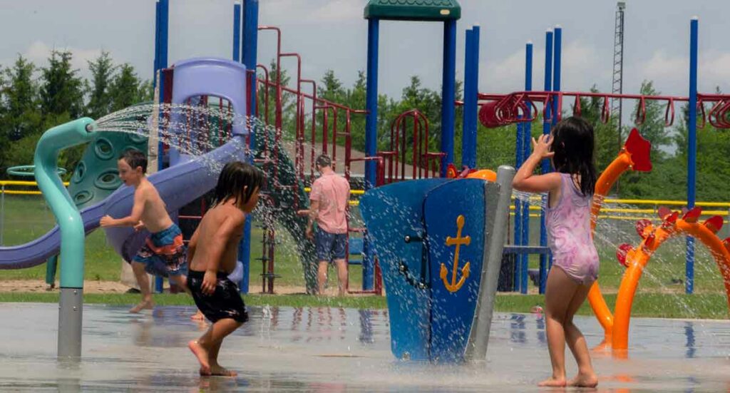
The splash pad located at Low Island Park is fun for all ages.
Got kids? Bring them here to swim at the beach, get drenched in the waterspouts of the splash pad, run around the lawns and tucker themselves right out on the playground slides as you keep an eye out, all the while relaxing at one of the many picnic tables in Low Island Park.
The sprawling municipal green space and beach accommodate lots of recreational activities for all ages, with fields for ball and soccer, a skateboard park, a dock for launching canoes, kayaks and oneself into the water, a pavilion with washrooms and change rooms, walking trails, historical sites, all in a lush setting of big trees shading the aforementioned numerous picnic spots.
Julia Bay
Just past Gore Bay, stay on Hwy 540, headed for Gordon/Barrie Island. The highway becomes Hwy 540A as it curves westward; turn right (east) here to find Julia Bay beach.
The beach at Julia Bay.
Just past the Gore Bay airport, down a hill, around a curve lies Julia Bay and its alluring arc of sand. Julia Bay Beach offers a sandy, gradually sloping lake bottom and floating dock for sunning and jumping from. The view over the bay is grand; there’s a small gazebo at water’s edge, benches, a picnic table with sail awning, a big Manitoulin Cycling Routes map marked with the Barrie Island route and room to stretch out on the sand or the lawn.
It is generally quiet here but can fill up on those hot afternoons; out on the dock a young lad dives over and over into the cool, calm water then comes in to hop on his bike to head home.
Manitowaning
The beach in the village of Manitowaning, nestled on the southwestern side of Manitowaning Bay in the eastern Township of Assiginack, is a sprawling expanse of sand on a picturesque coastline that is steeped in history. All around this immense bay, over to the peninsula of Wiikwemkoong Unceded Territory in the east, resonate the stories of the determining treaties, signed on these shores by the Anishinaabek and the British Crown almost 200 years ago, of the legends of an underwater ‘den of the Great Spirit,’ or ‘Manitowaning’ in Ojibwe.
To visit the town of Manitowaning is a multifaceted cultural experience that brings to life the story of settlement in this area. Preceding or following a trip to the beach, a stop in at the Assiginack Museum on Arthur Street and a look around interesting landmarks will paint a complex and fascinating historical panorama.
Drive, walk or bike down Queen Street toward the water and Bay Street, where stand the imposing frame structures of the Manitoulin Roller Mills (one of the finest examples remaining in Ontario) and the Burns’ Wharf warehouse (both built in the 1880s), sided by the Norisle, a steam-powered ferry built in 1946 that carried passengers and cars between Tobermory and South Baymouth until 1974, when the Chi-Cheemaun began her tenure of that run.
We’ve reached the Manitowaning Heritage Park and Marina, and the beach, richly deserved after touring through time. There’s ample parking and a bike rack and the beach is spacious and sandy; all along the beach locals from Wiikwemkoong, Manitowaning and further afield chat at several picnic tables; a long dock sees swan dives and cannonballs expertly executed off the boards; kids dig a hole atop a big hill of sand. On the far side is a sandy playground and a gazebo with more picnic tables, and by that side of the dock is a cordoned-off section of water for shallow bathers.
Misery Bay
Have you had any misery on Manitoulin this summer? If not (it’s not that easy, being miserable here), no worries, we’re all about a well-rounded vacation, mini-break or staycation, so jump aboard the train (that’s a figure of speech, there’s no train) to Misery Bay Provincial Park. No, you won’t be miserable, and yes, there’s a beach.
The story of the name goes something like this: Back in the dawn of time (or, in the 1880s), two men in a boat in the bay called out to settlers cutting marsh grass in the hot sun on the shore, “What bay is this?” An overheated wag in the work party shouted back, “Misery!” and the name stuck.
About 30 kilometres west of Gore Bay on Hwy 540, Misery Bay Provincial Park is a natural marvel: a 1,100-hectare tract of undisturbed, protected land with over 15 kilometres of well-marked and maintained trails on four distinct routes. Misery Bay Provincial Park is classified as a nature reserve by Ontario Parks to protect “at the highest level” the alvars, wetlands, upland forests and animal and plant species at risk that are found here.
Take the 3.3 km Alvar Coast Trail to the beach in Misery Bay, a ‘moderate’ trail to hike, well-marked with red directional arrows. (The trail carries on along the coastline and loops back, a total of about eight km, but just to go to the beach and back is much shorter.) The slope down to the water is gently gradual, the path sometimes firm sand, sometimes flat, limestone alvars, sometimes pine-needle-strewn, always clearly discernible as it weaves through thick stands of trees.
Part of the extensive beaches at Misery Bay Provincial Nature Park.
Given the stunning geological environment in which the park is situated, it stands to reason that the beach will not be just your usual beach (never a bad thing in itself, of course), but also a geological wonder. And it’s a 20-minute walk, adding another healthy dimension to the beach experience; for this reason, a pair of shoes slightly sturdier than flip-flops is recommended for the trail. As on any hike, water and snacks are de rigueur.
This beach is indeed different; arriving on the shore of Misery Bay is a bit like stumbling into a movie set in primeval times. Water levels have receded since last summer’s high levels submerged all of the beach, but are still not as low as in recent years, when the now-lake-bottom became visible, alvars stretching out as far as the eye could see.
You’d have to go out farther to actually swim, but everyone here seems content to explore the unusual terrain and to stretch out on the huge flat rock bed a few inches above the water; adults and kids linger and splash around the edges, sitting and standing in amazement.
The park is for day use only; no camping is allowed. Day use fees are in effect only on Friday, Saturday and Sunday. There is no charge for day use from Monday to Thursday until September.
The washrooms are open seven days a week.
So, what are you waiting for? Grab your towel and hit the beach! For more beach adventures (and you’ve got options!), be sure to pick up a copy of the handy Explore Manitoulin tearaway visitor’s map found just about everywhere!
Some communities embrace the concept of large, wall-sized artwork, murals, while for other towns, the idea is a non-starter.
Nearby Sudbury hosts its annual “Up Here Festival” and invites muralists to tell their stories on the large canvases that the walls of buildings provide. In fact, a redundant hospital complex there has been muralized in an epic way. On Vancouver Island, the town of Chemainus has purposely made itself a tourist attraction because of the large pieces of artwork that can be seen everywhere.
On Manitoulin, the idea of murals has been an organic one with these large works of art appearing in our various communities independently and motivated by a variety of inspirations.
But we have them and they’re wonderful opportunities to “put yourself in the picture” with a selfie posed in front of each of them; a mini tour.
Here’s what you can find, and where.
We’ll start our mural tour with the North Channel towns of Little Current, Kagawong and Gore Bay, respectively.
The town of Little Current boasts two murals, each quite different from the other and each located in the downtown business area.
Canada Post has renovated the Little Current Post Office as a concept space, one of two such projects nationally. (The other is in Saskatchewan.)
The federal Crown Corporation determined to renovate and decorate its space, inside and out, with a nod to the well-established Woodland School of First Nations art which thrives on Manitoulin Island.
In its research, Canada Post approached the owner/curator of Spring Bay’s Perivale Gallery, Sharon McMullen, for advice and Ms. McMullan wisely presented some of the works of Duncan Pheasant for consideration. As it turns out, Duncan Pheasant is an Indigenous artist who happens to live in Little Current so when two of his pieces were chosen for the concept renovation, it was a nice fit.
On the front of the downtown waterfront building, one of Mr. Pheasant’s landscapes is presented in large format and inside the building, a large canvas in the recognizable Woodland Art mode is prominently hung. Mr. Pheasant has titled the outside piece “We are the land” and says, “the land has spirit, and we are the land.”
Here is Duncan Neganigwane Pheasant presenting his mural entitled “We are the Land”.
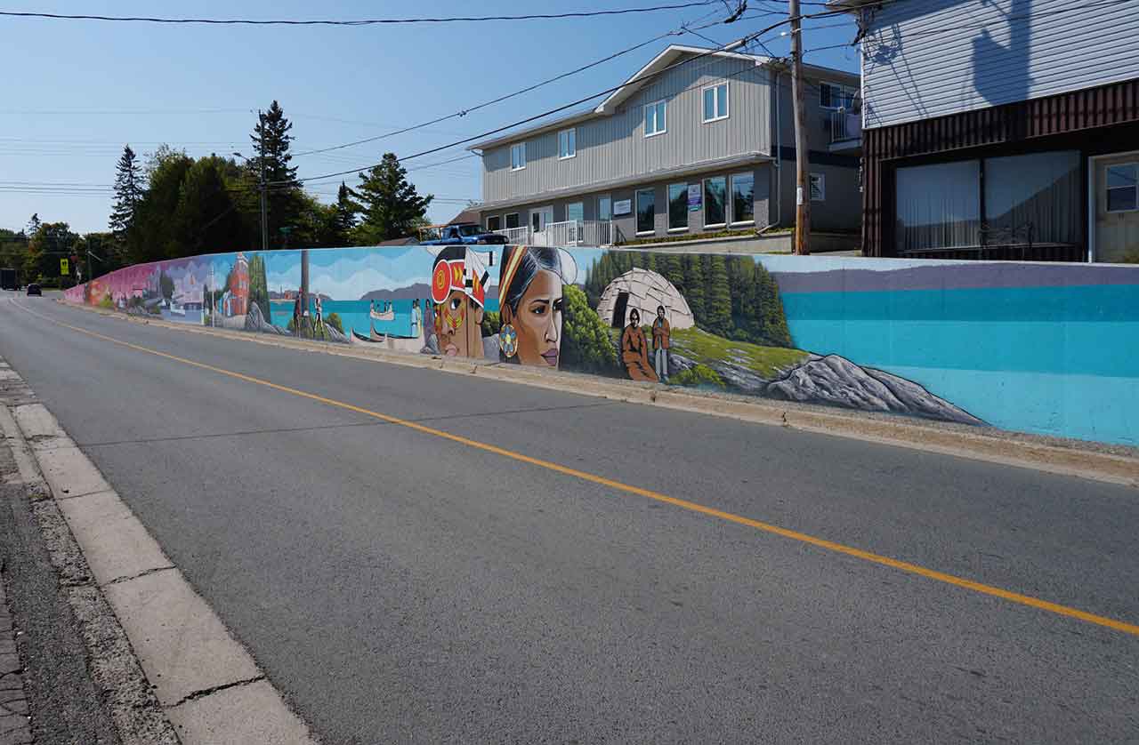
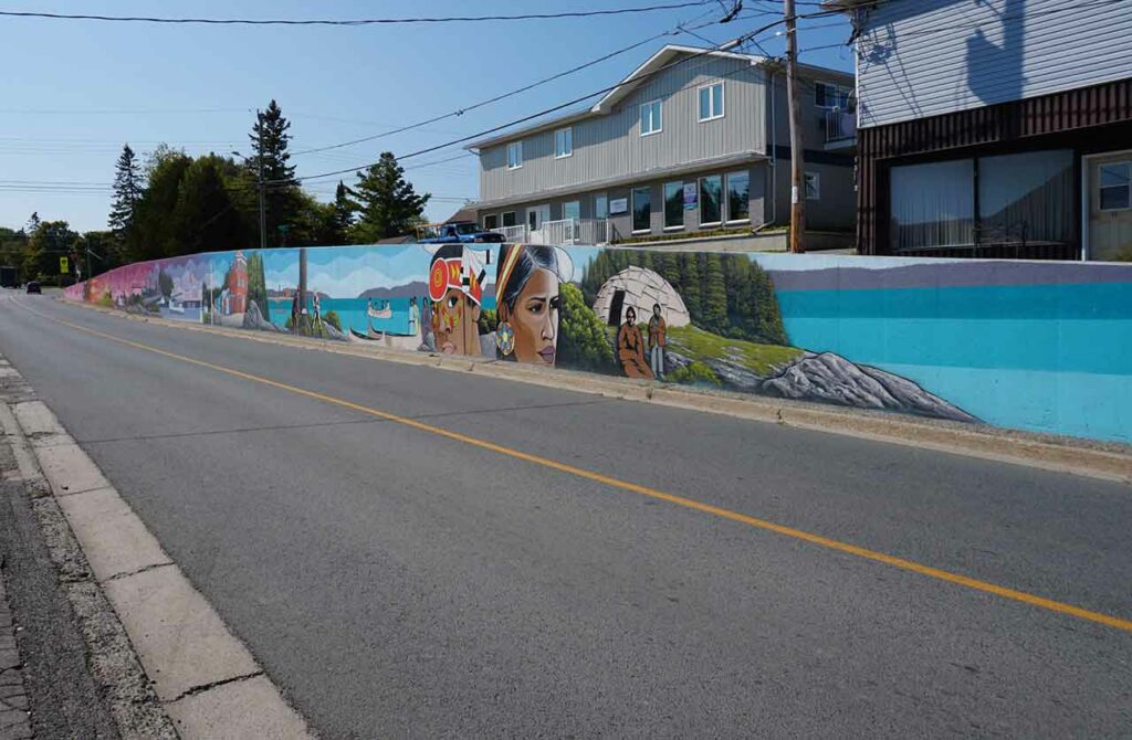
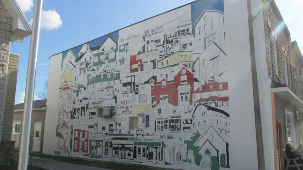
Just around the corner on Worthington Street/ Gore Bay highway, is Little Current’s second offering: a very large piece of artwork presented on a retaining wall that supports an unusual elevated street.
This mural has been in place since Canada’s 150th birthday and celebrates the long history of the community with landmarks colourfully illustrated.
This mural in downtown Little Current represents the community’s evolution. Photo courtesy of SA•WAT•SKI Concept Reality.
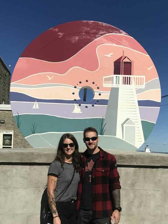
Taking Highway 540 west to the village of Kagawong, styled as “Ontario’s Prettiest Town” for good reason, that community’s mural can be found decorating a very large fly wheel that is set on its pedestal on the waterfront in front of the Old Mill building that has been repurposed to house the municipal offices, the town’s museum and, upstairs, an art gallery (Edwards Studios).
There is another nice coincidence here, similar to a Little Current artist’s work being chosen for a Little Current installation.
Responding to a call for proposals to re-define the community through the images on the flywheel, sister and brother artists and designers Kendra and Morgan Edwards’ proposal was chosen in competition and they are the children of the aforementioned couple who operate the nearby Edwards Studios.
The newly muralized flywheel at the Kagawong waterfront, with the historic old mill in the background, is a great place to help memorialize your Island holiday as this couple, visiting from Northwestern Ontario, did last summer.
The mural’s dominant feature is the Kagawong lighthouse which a visitor can find on the main street across from the Austin H. Hunt Marina. The LaCloche Mountains, on the North side of the North Channel (and visible from the Kagawong waterfront), are represented by the blue horizontal element.
The Kagawong installation is also a waterfront attraction and is situated close to the downtown sandy beach and children’s play area, as well as to the interesting museum.
Stephanie and Troy Rubach from Red Rock, ON. posed infront of the newly decorated flywheel mural.
Twenty kilometres further along Highway 540 brings you to Gore Bay and another downtown installation. It is large, approximately 23 feet by 40 feet.
It too is an historical perspective, primarily of the town’s business and institutional community buildings over the last half of the twentieth century.
The work was completed in 2019 by Marcus Mohr and is an enormous recreation of a collage painting done by the late Gore Bay artist Jack Whyte.
The collage is readily visible from the main street, and is presented on a high, wide wall that is conveniently accessed by a pathway that leads to the municipal office and library complex and also runs beside the historic Gore Bay Town Hall, home of the famed Gore Bay Summer Theatre.
The mural in Gore Bay depicts the town’s business and institutional community buildings over the last half of the twentieth century.
The next stop on this mural tour can be Providence Bay, a straight shot south from Gore Bay via Highway 542, a community located on Manitoulin Island’s Lake Huron shoreline.
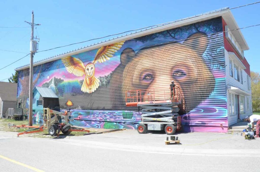
This south shore community’s mural is by far the largest and takes up the entire side and front walls of the Mutchmor Gallery.
When the building was repurposed from a hardware and building supply emporium to an art gallery, Peace Café and loft rental accommodations, the owners decided to enhance their property’s “destination” status by commissioning an epic work of art on the building’s long side wall.
The Mutchmor Gallery owners encountered the mural firm Essencia working on a very large piece in Toronto and were so taken by their work that they asked the company to come to Manitoulin and give their property, and Providence Bay, a new landmark.
The result is a mural that is dominated by an enormous bear’s face looking out at Mutchmor Street with a colourful hawk on the fly keeping him/her company. There is lots more going on as well but the mural, and the community, are well worth a visit.
This Providence Bay mural adorns the side of the Mutchmor Gallery.
And now to Manitowaning, again in the downtown area, specifically to the Debajehmijig Storytellers Queen Street location and its neighbouring building.
The building houses a versatile theatre space and, when it was conceived and built, a large garage-type door was fitted to the theatre’s street side so artists’ work can spill outside the black box space and into the community.
The mural on this large door is the work of Barry Beaver, a Cree artist from Wabasca First Nation and a former Debajehmujig artist-in-residence.
The work depicts the battle of the thunderbird and the lake monster and the muralist’s work also adorns wall panels on the neighbouring residence.
Besides housing the theatre group, the Debajehmujig building also is home to the Kathleen Mastin Art Gallery.
These outdoor installations are each unique and were put in their places at different times and for reasons unique to each one of them.
A tour of them all, like the lighthouses of Manitoulin (the accessible ones) is a good reason to take to the roads and enjoy the scenery on the way from destination to destination.
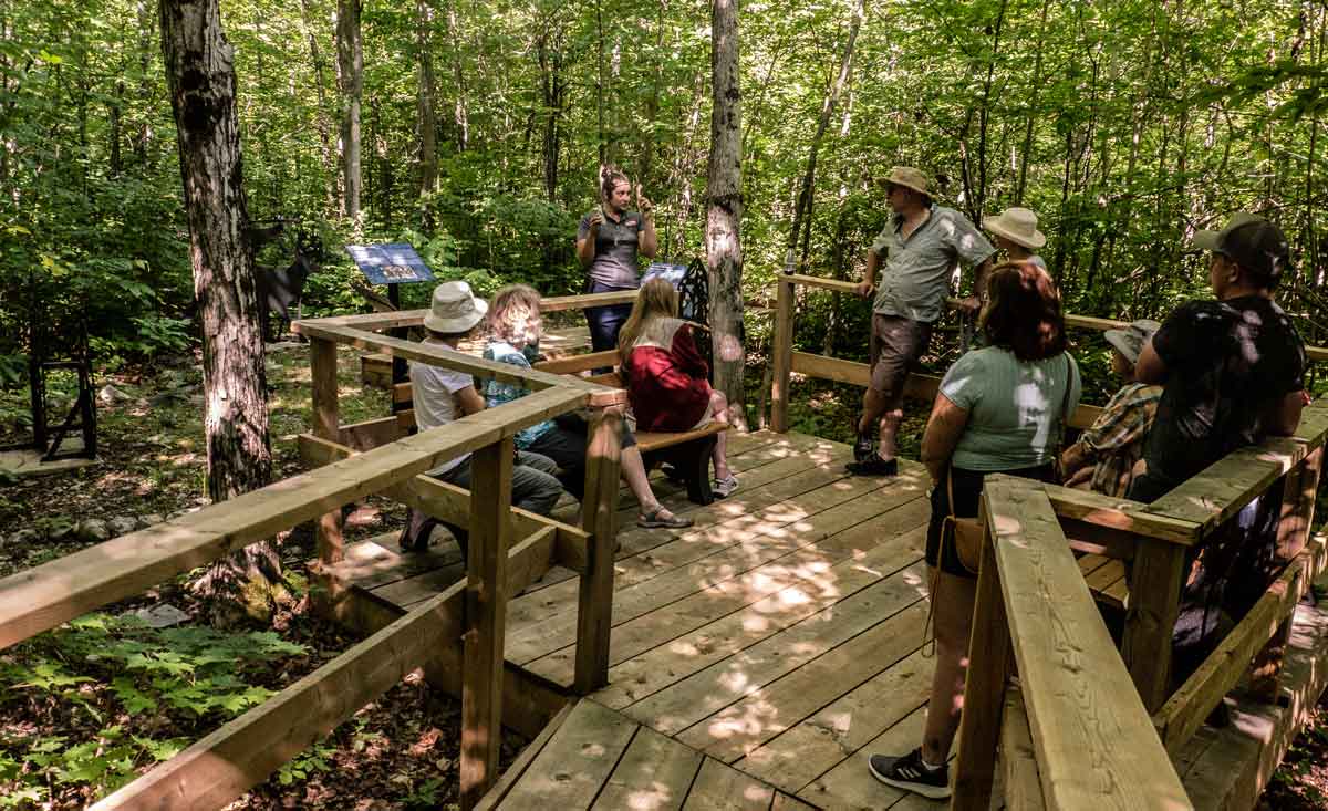
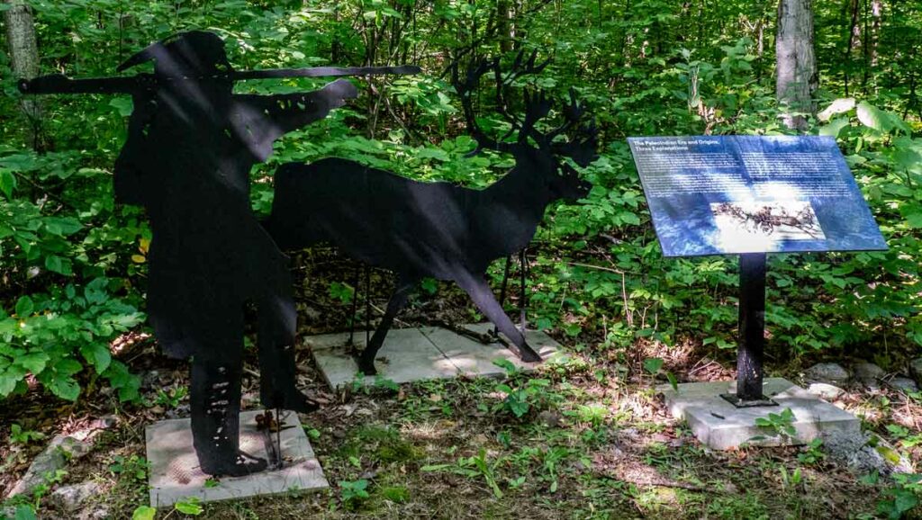
Taking a guided tour through the Sheguiandah Archaeological Site is unlike any other Manitoulin Island experience. To climb the newly opened boardwalk up the small hill on the edge of the pretty village of Sheguiandah south of Little Current is to enter an enchanted forest enclosing thousands of years of geological and cultural history.
The uncovering of this prehistoric place began just over seventy years ago, in 1951, when Thomas E. Lee, an archaeologist with the National Museum of Canada, found ancient stone implements in a farm field near here. Lifting his eyes upward to this very hill – so the legend goes – he spotted something shiny glinting in the sun at the top.
After ascending the knoll, Lee and his team realized they had come across a small part of the region’s two-billion-year-old Precambrian geological formation. Also known as the Canadian Shield and rare amongst Manitoulin’s younger rock formations, the glittering object Lee had seen was a knob of the original white quartzite bedrock poking out of the earth that had been laid down around it in successive layers over millions of years. Upon beginning their archaeological digs, they found dug pits and artifacts of the Island’s first inhabitants, Indigenous peoples drawn here by the hard and durable stone’s great utility in quarrying tools and spears.
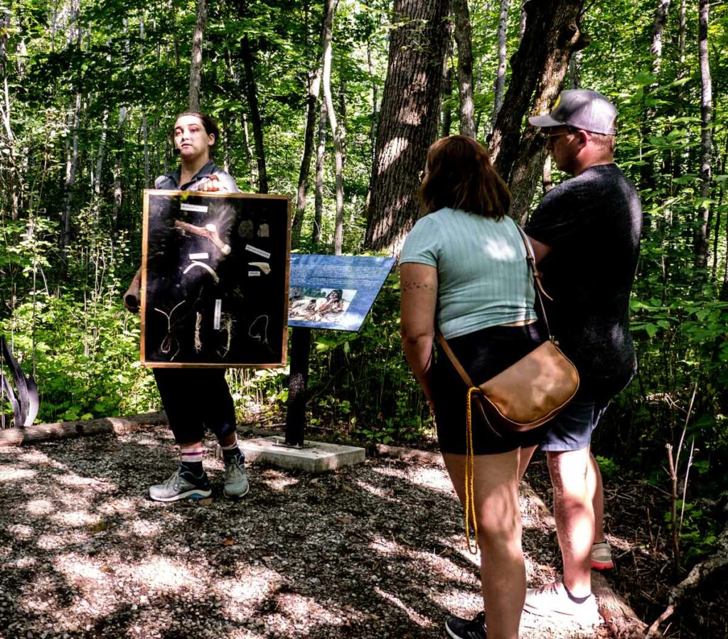
Tour guide Olivia Fetterly (left) discusses some of the artifacts found by archaeologists during early excavations of the site in Seguiandah. Photo by Isobel Harry.
In 1954, the hill, quarry and habitation area that encompass the village of Sheguiandah were designated a National Historic Site of Canada. But after Lee’s initial excavations, the site lay dormant for over forty years.
Then in 1991, geo-archaeologist Patrick Julig of Sudbury’s Laurentian University, Peter Storck of the Royal Ontario Museum’s anthropology department and a team of specialists re-opened the quarry site to re-examination. Julig and Storck’s new analyses dated the site at 9,500 carbon-dated years after the last Ice Age, or about 11,000 calendar years ago.
Since relocating to Sheguiandah with his wife, Helen, in 2002, Dr. Julig has continued his involvement with the adjacent Centennial Museum of Sheguiandah, designing an interactive display of maps, descriptive details and archeological artifacts and realizing a long-held dream of guided tours at the site. Finally, after extensive work aimed at ensuring that the fragile site remains undisturbed even as it is visited by the public – it is protected from any encroachment by the Ontario Heritage Act and the National Historic Site designation – and after postponements caused by the pandemic, tours began last summer.
According to the Canadian Register of Historic Places, “The heritage value of the remains found in Sheguiandah resides in a series of successive cultural occupations of early inhabitants in what is now Ontario, beginning circa 11,000 B.C.E. with the Paleo-Indian Period during the recession of glacial Lake Algonquin.
“The site also contains artifacts from the Archaic Period (1000-500 B.C.E.) as well as Point Peninsula Culture stone tools associated with the Middle Woodland Period (0 – 500 C.E.).”
Now, for the first time, site tours offer the exhilarating opportunity to experience these ‘successive cultural occupations’ and geological eras one after the other, led by an experienced guide on a walk back in time.
From the present day entrance on Lake Huron’s Sheguiandah Bay, our guide, Olivia Fetterly, a knowledgeable graduate of Nipissing University in biology and fine art, stops at regular intervals to describe the beach levels corresponding to the different periods as we go up the hill. Along the leafy route descriptive plaques and evocative iron sculptures denote the activities that took place here, offering an exceptional ‘living lesson’ in the prehistory of Manitoulin Island as we walk.
The natural landforms are a geological record of the ancient glacial lake waters receding through time as the glaciers melted – remaining at one level for millennia, carving a step, or beach, into the ridge – down to the modern water level of Lake Huron that we know today. Similarly, as we go up the Sheguiandah Site hill, each new beach level is higher and older geologically than the last, ending with the oldest part of the site at the top, where Thomas Lee had first spotted the quartzite protuberance from the field below.
From the edge of the bay to the trailhead, just a few hundred yards up a low rise, we have already gone back in time two thousand years, to the first ancient raised beach terrace on this walk (or the last, and earliest, if you count back from the top level), the 2,000 year-old Algoma water level. Here lived nomadic people known in anthropology as ‘Middle Woodland,’ tribes that traded copper goods, shells and flint tools, made pottery pipes and vessels, wove baskets and worked hides.
“The people kept coming back here to work the site,” Dr Julig has said. “They first arrived to work the quartzite at the top and, as more and more land became exposed as the water lowered over thousands of years, succeeding groups of nomadic people arrived to quarry and live here for brief periods.”
Our guide ensures an immersive experience by showing a range of fossils, bones and tools that were found here, and by pausing to point out some of the plants that were used for food, such as acorns and wild leeks, medicines, like chaga mushrooms, and for tools like axe handles and ropes.
Positioned along the trail are evocative iron sculptures depicting scenes of prehistoric life and descriptive signs of the geological formations to be found in the Archaeological Site. Photo by Isobel Harry.
We continue our gentle ascent along the boardwalk, punctuated by some steps and resting on benches on the decks, captivated by our guide’s stories of early peoples and accompanying fascinating geological facts. Upward we go, noting the change in vegetation, from spruce forests to pine, followed by hardwood forests and into the hillside quarrying area where pits were dug into the quartzite bedrock. We learn about the carbon-dating process and why Thomas Lee’s estimates of time periods for the site differed from later, now standard, opinions.
Having risen up beyond the Nipissing Bluff beach level (5,500-6,000 years old) that is associated with the Archaic-era peoples, past the Mystic Ridge ‘storm beach’ that dates to 450 million years ago, we see lines of quartzite rocks in what is known as the Habitation Area, marking Thomas Lee’s excavations. In the area of the Korah Bluff, we enter the Paleo-Indian era at the top of the hill, in the time of the first Indigenous inhabitants of the Americas, about 11,000 years ago.
We’ve gazed down into large pits where the quartzite that is still seen here in big and small chunks first began to be quarried. We’ve imagined the encampments of the hunters by the earliest lakes, building fires for cooking and warmth and chipping stone into spear points and knife blades. We remembered there were caribou on the Island eons ago, and birch bark canoes filled with copper and clay goods for trading over the water. And now we’re at the top of the ancient hill that has yielded so much mystery and history for thousands of years, fixing our eyes in wonder on the quartzite at our feet and toward the Georgian Bay far off in the distance.
Once we trek back down to the site entrance, we’ve only been a couple of hours on the trail, but our prehistoric reverie is destined to last much longer. Because, luckily, we hold the beautifully crafted field guide given to participants at the end of the tour to remind us that we did not just imagine this magical place.
Tours must be booked ahead at https://shegsite.com or by visiting the Centennial Museum of Sheguiandah, 10862 Highway 6, Sheguiandah.
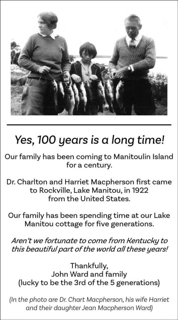
Last August, an unusual ad appeared in the Manitoulin Expositor – headed by a vintage photograph of two adults and a child standing on the edge of a lake holding a long stringer of fish, the words below begged for further investigation.
This is the advertisement placed in The Manitoulin Expositor in the summer of 2022.
“Our family has been coming to Manitoulin Island for a century,” they said. “Our family has been spending time at our Lake Manitou cottage for five generations…. Aren’t we fortunate to come from Kentucky to this beautiful part of the world all these years!”
Signed, “Thankfully, John Ward and family (lucky to be the 3rd of the 5 generations),” the words further described the people in the photo as “Dr. Chart Macpherson, his wife Harriet and their daughter Jean Macpherson Ward.”
Well, that’s all it took to get the newspaper to assign this intrepid reporter to the case, to send her speeding toward the Rockville Road, searching for the (almost) unmarked turnoff to Lake Manitou’s edge and the (sort of) secret cottage by the previously unknown (to her) pretty little inlet in the Island’s largest inland lake. (It is also the largest lake on a freshwater Island in the world, according to the Guiness folks.)
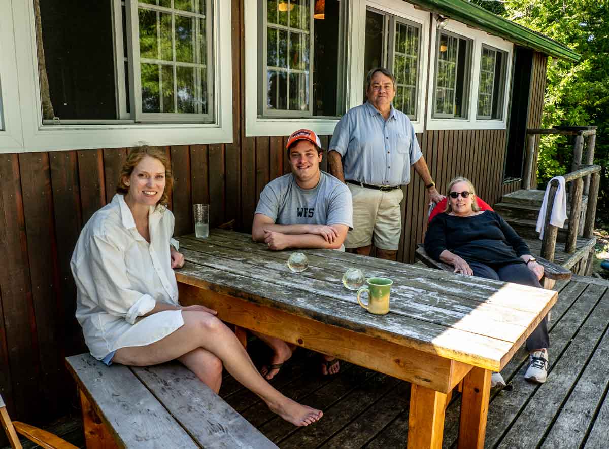
There, tucked into a cedar grove on a small elevation overlooking a few boats moored in a charming old-time landing is the Ward family cottage. And here is the patriarch, John Ward 1V, greeting this writer warmly at the open front door with Phyllis, the spirited matriarch of this American family.
Radiating hospitality, the couple makes sure the visitor is comfortably ensconced as they tell the story of the family’s happy landings on these shores in the 1920s.
John Ward’s great grandfather, Dr. Charlton (‘Chart’) Archibald Macpherson, was born on the island of St Thomas in the US Virgin Islands, and attended medical school in Toronto. His medical residency was at Harper General Hospital in Detroit and afterwards he and his wife Harriet decided to remain in the US, settling in St Clair, Michigan where he became the town’s surgeon.
One summer, sailing up the St Clair River into Lake Michigan and then into Lake Huron, the Macphersons’ vessel ran aground at Little Current on Manitoulin Island; while their boat was being repaired, the Macphersons stayed at a family-owned resort on Lake Manitou.
“In the 1920s, the Spry family farmed on the Rockville Road and ran a tourist lodge on Lake Manitou,” explains John Ward. “They had cows and chickens and some rental cottages for tourists. My grandparents stayed in one of the cottages and ate their meals in the main lodge; they returned every year after that first visit to relax and do some fishing. They just loved it here. So much so that when the Sprys sold their place and the new owners, the Chisholms, sold off some of the land, my grandfather bought a piece and built this cottage, with a porch, two bedrooms and an outhouse, By then, in 1946, he was spending a lot of time here and had taken up painting.”
Today, we are sitting in the vertical log cabin that Chart Macpherson built, By today’s sprawling standards, it is tiny but retains all the charm of those bygone days – when cottaging meant camping out and the amenities we now take for granted, like electric lights and indoor toilets, were unheard of – although it has since been updated to include modern facilities.
The dimly lit interiors lined with dark wood logs, the small windows, the built-in cupboards, breakfast table and benches, keep everything compact and focused on the expansive view outside the screened-in porch windows, including a patio and a rustic stairway down to the dock and the lake. You get the feeling that everything that is most essential about cottage life is here; all the simple pleasures that matter most, just like in the old days: the huge inland lake, fishing, swimming, card and board games, good summer friends, endless dog-days, unearthly peace and quiet and starry, starry nights.
Charlton and Harriet’s daughter, Jean, the young girl in that vintage photo who’s helping her parents hold the stringer of a dozen fat fish, is John Ward IV’s mother. She married Jack Ward III after the second World War and while they moved to Kentucky, the pull of Lake Manitou memories kept her coming back with her husband every summer, eventually with their baby son, John Ward IV.
“As a child I slept here in my grandparents’ cottage while my parents rented a cottage next door,” says John.
“We come to recharge,” adds Phyllis. “Kentucky is far too hot in summer. We drive ten hours to get to the ferry; we used to just get in the car and drive until we got to the cabin. Now we stop for the night in Sarnia.”
John Ward IV is the third generation of his family to spend summers at the Lake Manitou hideaway, and he and Phyllis are enjoying a visit by daughter Elizabeth, son-in-law Charles – who proposed here in 2016 – and their beautiful baby, Jane, “who just loves the water!” This young family, making up the fourth and fifth generations to summer in this cabin, drive eleven hours from Richmond, Virginia to enjoy the lake, an annual climb up the Cup and Saucer and “the stunning natural beauty of the diverse landscapes” of the Island.
Charlton and Harriet Macpherson first experienced Rockville and Lake Manitou in the 1920s, just as the automobile expanded the boundaries of travel and tourism into the Island’s first farm settlements of the 1860s and 70s. Their sense of having found somewhere special has been passed down through succeeding generations that continue to treasure their ancestors’ serendipitous discovery so long ago.
“We are incredibly fortunate that our family had the foresight to build here seventy-five years ago; we are still so grateful to them.” Photo courtesy of Shutterstock.com
As the Ward family settles onto the patio on this hot afternoon, with the lake shimmering down below, John Ward IV, still disbelieving his good luck in finding himself here after all these years and perhaps wanting to acknowledge an intangible debt owed his forbears, sums up his deep affection for this long-loved sanctuary: “We are incredibly fortunate that our family had the foresight to build here seventy-five years ago; we are still so grateful to them.”
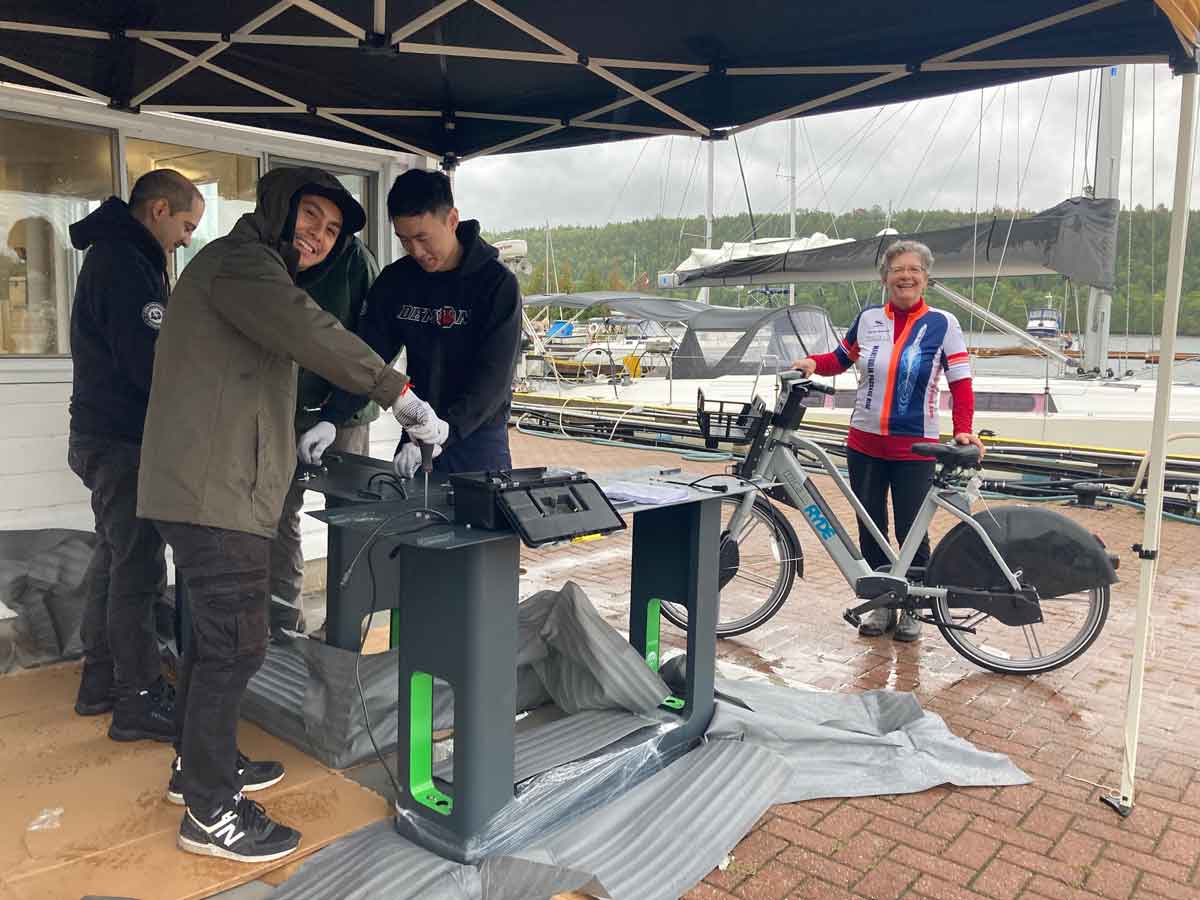
As always, MICA (Manitoulin Island Cycling Advocates) is on the move – and making it easier for you to move too!
During the past year, MICA’s new electric bicycles program got off to a fast start with the installation of seven e-bike charging stations around the Island. “In 2023,” says Maja Mielonen, MICA’s passionate president, “active living enthusiasts who reside here or visit can choose from our current fleet of twenty e-bikes to tour Manitoulin, run errands or go to work with ease from May to October.”
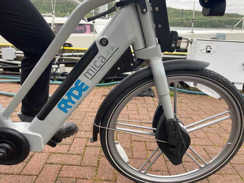
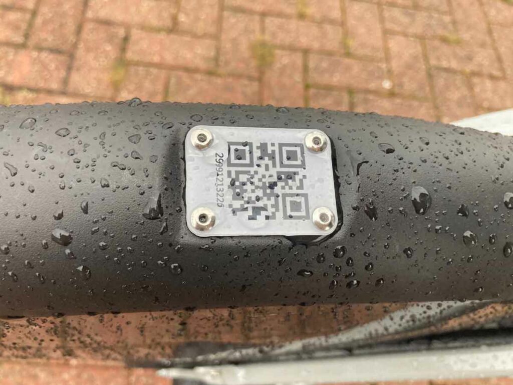
Booking an e-bike is straightforward with the Ryde app that can be downloaded onto an iPhone or an Android phone right from MICA’s website (www.manitoulincycling.com/e-bikes). The app lets you find your ride’s charging station on a map, reserve your time slot and, once there, allows you to wave your phone at the QR code on the bike and you’re good to go. E-bikes may be left at any charging station after your ride.
“Enthusiastic” barely describes Ms Mielonen’s zeal for e-bikes. “Their range is 65 kilometres, they have non-puncture tires, a wide seat and a basket,” she explains, with ‘what more could you ask for?’ being implied. “You just pedal and the assist kicks in. You get up to speed right away and quickly learn how to brake or just stop pedaling; there’s no shifting. The learning curve is short
“Immediately you go, go, go. The battery takes over the bike. It goes 32 km an hour and when you pedal the motor gives you a boost so you can keep going without tiring yourself out. E-bikes are allowed on trails because of their top speed and you only need a helmet if you’re under 18.” Pedaling is also more fun, extends the range of your battery and the life of your motor and is good exercise too.
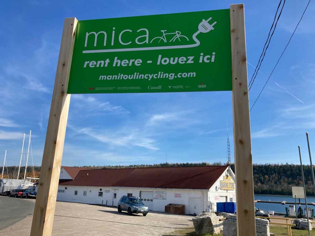
Look for the signs: MICA e-bike rental locations (listed on the MICA website) are found near bright green signs like this one at
the Gore Bay Marina. Photo by Isobel Harry.
The charging station locations on Manitoulin Island are at the Marina in South Baymouth, the Assiginack Township office at 156 Arthur St. in Manitowaning, the Town of NEMI office at 14 Water Street in Little Current, Kagawong Marina, Gore Bay Marina, the Information Centre, 2207 Hwy. 551 in Mindemoya, and at the Community Centre at 11 Mutchmor St. in Providence Bay.
As of this writing, exact fees had yet to be determined but are anticipated to be in the range of $15/hour and $90/full day.
Also new and exciting on the MICA menu this year are three ‘Accompanied E-Bike Adventures,’ each for five days and four nights in June and September that include e-bike rental, accommodation, guide accompaniment and support, four breakfasts, lunches and dinners, roadside snacks, entrance fees to many pre-planned, cool cultural experiences, and gratuities. Full details are at www.manitoulincycling.com/events/guided-e-bike-adventure-on-manitoulin/
MICA works hard to cover all the bicycling bases on the Island, from their tireless advocacy efforts on behalf of paved highway shoulders, ‘Bicycle Route’ signs on municipal roads along with cycle racks in choice locations and eight trailhead installations for route mapping, to their Manitoulin Cycling Map with fourteen routes over 850 kilometres available for downloading or to order for $2 from the website. Further encouraging self-guided touring, their website listings under ‘Eat, Sleep, See’ enhance the experience.
Never content to rest on a heap of successful achievements, MICA had yet another initiative up their sleeve for a Spring, 2023 launch: the Manitoulin Outdoor Digital Experience Museum (MODEM).
With the backing of Fednor’s Tourism Recovery Fund and Destination Northern Ontario, MICA hired ‘story collectors’ to compile anecdotes, photos and film and video clips from all over the Island to be integrated on an app, similar to ones now common in museums around the world.
“MODEM is a digital tour guide at your fingertips,” Ms. Mielonen explains.
Booking an e-bike is straightforward with the Ryde app that can be downloaded onto an iPhone or an Android phone from MICA’s website. Photo by Isobel Harry.
“Using the app at the seven MICA e-bike locations, riders are guided past points of interest and at certain GPS locations one can read, listen and view the story attached to that location in English and French.
“MODEM is a tool that increases the knowledge of our Island’s diverse history, environment, fauna, flora and the stories of the people living here; it will create a deep sense of place, a healthy sense of pride and the will to protect them,” said MICA’s president in an interview with the Manitoulin Expositor when funding was announced last year. Plans include free distribution to the Rainbow District School Board for use on student field trips.
The Ryde app lets you aim your phone at the QR code on the bike and be on your way. Photo by Isobel Harry.
And so MICA rolls on, initiating and refining their cycling programs and fueling the noticeable increase in riders on Manitoulin.
Bookings were open last fall for the annual (and free) Passage Ride for cyclists (June 3-4, 2023); sold out last year, 250 riders boarded the Chi Cheemaun ferry with their bikes for two days of Island touring, including lunch and a dinner-dance.
MICA’s popular guided Alvar Cycle Tours of the Island continue to be offered, with five dates in June and September, 2023, including accompanying car escort for pannier-free riding.
Maja Mielonen delights in telling of “the two single riders who met on an Alvar tour in 2021 and are now a love story to be told!”
This is what’s really important, she says: “MICA brings joy!”
You might need a few trips to Manitoulin Island if you want to match the ambition of Islanders Kristin Bickell and Nat Hastings, two long-time friends who have made it their mission to paddle the circumference of every inland lake on Manitoulin, but even a day trip around one of the glimmering waterways might offer enough beauty to satisfy your quest for an adventure on a more manageable scale.
“We’re both people who are up for a challenge; we have a hard time saying ‘no’ to things. It’s just a way to challenge ourselves to stay active on the water and continue to explore Manitoulin,” said Ms. Hastings. “Right now, with what’s been going on with COVID-19, it’s even more of a reason to stay put and explore in our own backyard.”
This isn’t the first canoe-bound adventure for Ms. Bickell and Ms. Hastings. The two successfully circumnavigated the whole Island in a canoe over 13 days during the summer of 2019. Trying to cross off all the inland lakes seemed like the next natural progression.
Last year brought mixed results—they had great times on the smaller water but could not reach as many lakes as they first hoped. This was a teachable moment for them about making extensive plans rather than ‘winging it,’ as they shared with This is Manitoulin, noting they are planning a more structured approach for this year.
Whenever heading out on an outdoor adventure, it’s important to remember that there are always plenty of factors beyond one’s control, from weather to fatigue to an unexpected emergency.
The first step in planning a successful paddling trip is making sure you have the right amount and type of gear, starting with safety essentials. These include wearing properly fitting and up-to-code life jackets, making sure your boat is in good repair and that you have the right paddles to get the job done. An emergency kit is a must-have, which will feature a rope, whistle and waterproof flashlight, ideally within a small bucket-like container that can double as a bailing device if needed.
You’re free to add more items as you see fit, such as a compass, but it’s also important to make sure you don’t overpack and have too much gear to manage effectively.
Once your kit is ready, it’s time to plan out your ideal voyage. When selecting a lake, it’s probably best for beginner and mid-level paddlers to avoid the big water of Lake Huron and even some of the larger inland lakes like Lake Manitou, unless you know the area. These waters can be unpredictable and treacherous so starting with an easily accessible spot is generally a good plan.
A stop at a tiny beach on Manitoulin’s rugged Lake Huron shoreline. Photo by Warren Schlote
“Mother Nature is boss and she reminded us of that many times. The Island’s shorelines are rugged, the surrounding water is intimidatingly big, and the smallest amount of weather out there can make for challenging paddling conditions,” said the paddling duo, stressing the importance of knowing your comfort zone and adventuring within your limits.
Bass Lake in Sheguiandah can be a pleasant paddle for new and experienced boaters alike. The duo behind ‘The Attempt’ journeyed its 8.4-kilometre shoreline as the first entry into their inland lake challenge last summer.
As Ms. Bickell and Ms. Hastings can attest, the scenery available on Manitoulin’s many lakes is varied and can offer years of new experiences while voyaging around more than 100 inland waterways.
“(The trip around Manitoulin) felt worth it all of the time. We got to see the Island in a way that was better than we could have ever imagined. It can be easy to forget that we live in one of the most beautiful places in the world and that all of this is within arm’s reach,” they said.
It’s always important to let others know of your plans just in case you should ever need assistance, whether they’re nearby or checking in from a distance. Besides, it never hurts to have someone to snap your next Instagram photo from the shore.
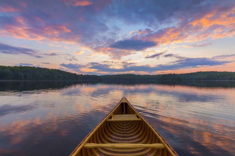
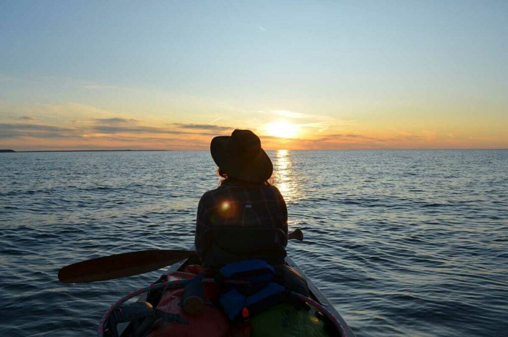
On the water you are guaranteed a sunset a day. Photo by Warren Schlote
The process of getting out on the water can seem intimidating for newer paddlers but thankfully, there are places on Manitoulin Island that can help you out.
If you’re looking for a quick way to see the hotspots on Manitoulin with an expert leader, other organizations like Wikwemikong Tourism offer guided adventures (Wiikwemkoong.ca/tourism/tours; 705-859-3122) including day-trip paddling treks and multi-day adventures over longer distances.
If you don’t have your own canoe or kayak, call ahead to check on the availability of rentals as this summer season unfolds.
As for the two behind The Attempt, they have their eyes set on crossing more lakes off their 2021 to-do list. It’s a rejuvenating activity in what’s been an otherwise hectic year for the pair.
“I think both Nat and I would agree that taking care of yourself is so important. Paddling in this beautiful landscape and all lakes that we have can do wonders for your mental health and happiness in general,” Ms. Bickell said.
Ms. Hastings and Ms. Bickell plan to make this year more interactive, featuring immersive tripping videos, safety advice, helpful tips and, of course, more gorgeous photos from their treks on the water.
To keep up with the progress during The Attempt, follow their adventure on Facebook by searching for the official page, @TheAttemptManitoulin.
The pleasures of a picturesque small village—a swoon-worthy crescent of palest-sand beach, evening strolls and serenades on the boardwalk, fish and chips, ice cream, Russian pancakes, fine dining … Aaahhh, Providence Bay in summer—the perfect Island getaway from your Island getaway, should you need one.
Providence Bay’s enduring attractions also include its nearly 150-year-old annual agricultural fair in August, a popular marina and a June bluegrass festival under the stars; vintage tourist cottages and tent and trailer parks, motel and lakeview B&B are always booked solid. In more recent history, new businesses have merged seamlessly into the country village vibe, adding much to the economic viability and lasting appeal of this tiny Island treasure.
At the centre of the village and steps to the beach, the 10,000 square-foot Mutchmor building can’t be missed: a vividly coloured mural covers the entire south-facing wall of the original furniture store and the McDermid hardware store that operated here since the 1930s.
In 2016, young entrepreneurs Matthew Garniss (who was already operating Lake Huron Fish and Chips up the street) and spouse Bridget Sarpong, imagining a combination of café, gallery and gift shop in the cavernous space, took the leap of faith required to purchase the building. Now, the renovated space, renamed after an early lumber entrepreneur in Prov (as the village is known to locals), is the bustling setting for the welcoming Peace Café with its communal table and benches, sofas and armchairs amid the sprawling bazaar of thoughtfully-chosen wares that takes up three quarters of the main floor, and a long gallery wall of art in front of which to enjoy your espresso.
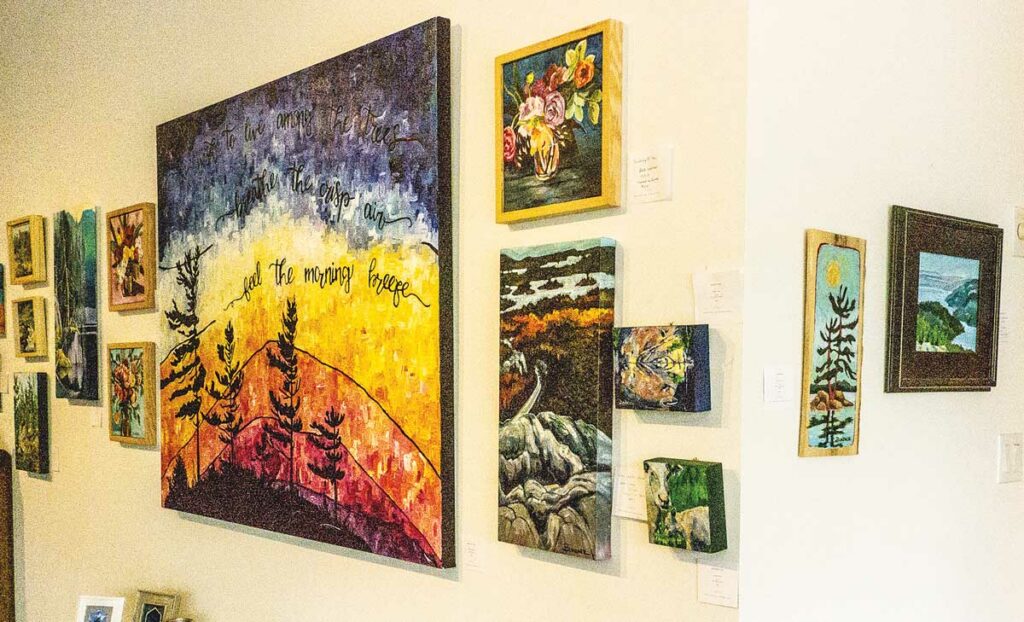
The Mutchmor’s long gallery walls. Photo by Isobel Harry.
“We wanted to be half-city, half-country, to expose people to broader communities,” says Matthew of their urban concept transplanted to this, well, much less urban outpost. “We’re a blend of rural and town, offering things you might see where you live, but many you would not see normally. We buy things that we love and that sell. For the vendors, the rent is not high, we can play around a bit every year with what works.”
Last season, the gallery featured Julieanne Steedman (Sudbury area and Manitoulin) and Beth Lindner (McGregor Bay), both artists of vibrant northern landscapes that visitors loved and bought. “The art we show at the Mutchmor is approachable and affordable. Bridget and I have picked up art in Marrakesh, in Ghana, Tibetan pieces—we want to show our excitement here about art from all over. The gallery, in the main space, will show one or two artists, or a group, each season,” adds Matthew.
We stroll through the market space, appreciating summer local Rick McKenzie’s photos on canvas, pottery mugs by Greg Voisin (Hamilton), the “functional and sculptural” pottery of daughter and mother Antje Hettmann and the hand-wrought jewelry of Ursula Hettmann (Manitoulin). Bridget and Matthew designed the t-shirts with retro fictional logos proclaiming ‘Camp Prov,’ ‘Prov Bay Pinecones’ and ‘Cold Lake Swim Club,’ much to the liking of the many who snapped them up last summer. There are photos by Vladimir Kabelik (Oakville), witty plexiglass pieces by Kazys Tamasauskas and photos by Jim Ryce (Toronto), soaps, leather bags, cushions, linen and screenprinted clothing, large dreamcatchers called ‘Aga Orbs,’ and an alcove off the main space devoted to Matthew’s dad’s vintage assortment of books, records and collectables.
Artful and eclectic, like Providence Bay itself.
Mutchmor Lofts, Gallery & Peace Café Open May to October Tel: 705-377-4703 www.themutchmor.com