by Isobel Harry
Taking a guided tour through the Sheguiandah Archaeological Site is unlike any other Manitoulin Island experience. To climb the newly opened boardwalk up the small hill on the edge of the pretty village of Sheguiandah south of Little Current is to enter an enchanted forest enclosing thousands of years of geological and cultural history.
The uncovering of this prehistoric place began just over seventy years ago, in 1951, when Thomas E. Lee, an archaeologist with the National Museum of Canada, found ancient stone implements in a farm field near here. Lifting his eyes upward to this very hill – so the legend goes – he spotted something shiny glinting in the sun at the top.
After ascending the knoll, Lee and his team realized they had come across a small part of the region’s two-billion-year-old Precambrian geological formation. Also known as the Canadian Shield and rare amongst Manitoulin’s younger rock formations, the glittering object Lee had seen was a knob of the original white quartzite bedrock poking out of the earth that had been laid down around it in successive layers over millions of years. Upon beginning their archaeological digs, they found dug pits and artifacts of the Island’s first inhabitants, Indigenous peoples drawn here by the hard and durable stone’s great utility in quarrying tools and spears.
In 1954, the hill, quarry and habitation area that encompass the village of Sheguiandah were designated a National Historic Site of Canada. But after Lee’s initial excavations, the site lay dormant for over forty years.
Then in 1991, geo-archaeologist Patrick Julig of Sudbury’s Laurentian University, Peter Storck of the Royal Ontario Museum’s anthropology department and a team of specialists re-opened the quarry site to re-examination. Julig and Storck’s new analyses dated the site at 9,500 carbon-dated years after the last Ice Age, or about 11,000 calendar years ago.
Since relocating to Sheguiandah with his wife, Helen, in 2002, Dr. Julig has continued his involvement with the adjacent Centennial Museum of Sheguiandah, designing an interactive display of maps, descriptive details and archeological artifacts and realizing a long-held dream of guided tours at the site. Finally, after extensive work aimed at ensuring that the fragile site remains undisturbed even as it is visited by the public – it is protected from any encroachment by the Ontario Heritage Act and the National Historic Site designation – and after postponements caused by the pandemic, tours began last summer.
According to the Canadian Register of Historic Places, “The heritage value of the remains found in Sheguiandah resides in a series of successive cultural occupations of early inhabitants in what is now Ontario, beginning circa 11,000 B.C.E. with the Paleo-Indian Period during the recession of glacial Lake Algonquin.
“The site also contains artifacts from the Archaic Period (1000-500 B.C.E.) as well as Point Peninsula Culture stone tools associated with the Middle Woodland Period (0 – 500 C.E.).”
Now, for the first time, site tours offer the exhilarating opportunity to experience these ‘successive cultural occupations’ and geological eras one after the other, led by an experienced guide on a walk back in time.
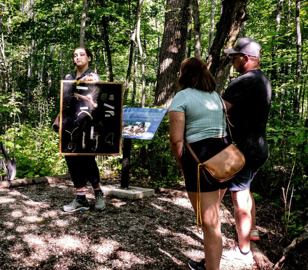
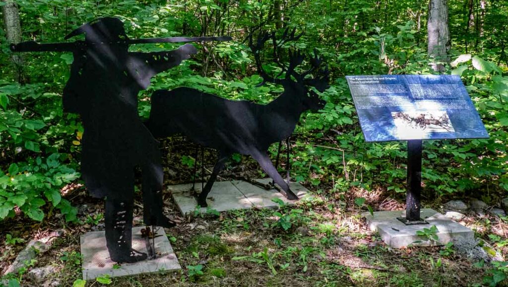
From the present day entrance on Lake Huron’s Sheguiandah Bay, our guide, Olivia Fetterly, a knowledgeable graduate of Nipissing University in biology and fine art, stops at regular intervals to describe the beach levels corresponding to the different periods as we go up the hill. Along the leafy route descriptive plaques and evocative iron sculptures denote the activities that took place here, offering an exceptional ‘living lesson’ in the prehistory of Manitoulin Island as we walk.
The natural landforms are a geological record of the ancient glacial lake waters receding through time as the glaciers melted – remaining at one level for millennia, carving a step, or beach, into the ridge – down to the modern water level of Lake Huron that we know today. Similarly, as we go up the Sheguiandah Site hill, each new beach level is higher and older geologically than the last, ending with the oldest part of the site at the top, where Thomas Lee had first spotted the quartzite protuberance from the field below.
From the edge of the bay to the trailhead, just a few hundred yards up a low rise, we have already gone back in time two thousand years, to the first ancient raised beach terrace on this walk (or the last, and earliest, if you count back from the top level), the 2,000 year-old Algoma water level. Here lived nomadic people known in anthropology as ‘Middle Woodland,’ tribes that traded copper goods, shells and flint tools, made pottery pipes and vessels, wove baskets and worked hides.
“The people kept coming back here to work the site,” Dr Julig has said. “They first arrived to work the quartzite at the top and, as more and more land became exposed as the water lowered over thousands of years, succeeding groups of nomadic people arrived to quarry and live here for brief periods.”
Our guide ensures an immersive experience by showing a range of fossils, bones and tools that were found here, and by pausing to point out some of the plants that were used for food, such as acorns and wild leeks, medicines, like chaga mushrooms, and for tools like axe handles and ropes.
We continue our gentle ascent along the boardwalk, punctuated by some steps and resting on benches on the decks, captivated by our guide’s stories of early peoples and accompanying fascinating geological facts. Upward we go, noting the change in vegetation, from spruce forests to pine, followed by hardwood forests and into the hillside quarrying area where pits were dug into the quartzite bedrock. We learn about the carbon-dating process and why Thomas Lee’s estimates of time periods for the site differed from later, now standard, opinions.
Having risen up beyond the Nipissing Bluff beach level (5,500-6,000 years old) that is associated with the Archaic-era peoples, past the Mystic Ridge ‘storm beach’ that dates to 450 million years ago, we see lines of quartzite rocks in what is known as the Habitation Area, marking Thomas Lee’s excavations. In the area of the Korah Bluff, we enter the Paleo-Indian era at the top of the hill, in the time of the first Indigenous inhabitants of the Americas, about 11,000 years ago.
We’ve gazed down into large pits where the quartzite that is still seen here in big and small chunks first began to be quarried. We’ve imagined the encampments of the hunters by the earliest lakes, building fires for cooking and warmth and chipping stone into spear points and knife blades. We remembered there were caribou on the Island eons ago, and birch bark canoes filled with copper and clay goods for trading over the water. And now we’re at the top of the ancient hill that has yielded so much mystery and history for thousands of years, fixing our eyes in wonder on the quartzite at our feet and toward the Georgian Bay far off in the distance.
Once we trek back down to the site entrance, we’ve only been a couple of hours on the trail, but our prehistoric reverie is destined to last much longer. Because, luckily, we hold the beautifully crafted field guide given to participants at the end of the tour to remind us that we did not just imagine this magical place.
Tours must be booked ahead at https://shegsite.com or by visiting the Centennial Museum of Sheguiandah, 10862 Highway 6, Sheguiandah.
Tel: 705-368-2367
Open May to October