
The impossible bridge: Past dreams of a road across Georgian Bay
Building a road between Manitoulin Island and the Bruce Peninsula might seem like the stuff of legends, an expensive and impractical project that would be challenging to plan, let alone build.
That’s because it probably is.
The current way to get between South Baymouth and Tobermory is on the Chi-Cheemaun ferry, a 43-kilometre distance in a straight line. But between those two towns lies the unpredictable big waters of Lake Huron, complete with drop-offs and shoals hiding beneath the waves.
Is a ferry the only way to connect that gap? Or could a more daring structure take shape, linking the two communities across a bridge or causeway for year-round access to the south?
If a hypothetical bridge were to be built along that line, it would be the eighth-longest in the world. The other eight are located in Asia, with most of them being viaducts for high-speed railway lines built over land.
Building a lengthy bridge over water would bring additional engineering and construction challenges. The longest bridge in Canada is the Confederation Bridge, which links Prince Edward Island and the mainland. It cost more than a billion dollars to build and stretches just 13 kilometres. For comparison, that distance is not long enough to reach Fitzwilliam Island, along the ferry route, from either South Baymouth or Tobermory.
Then, there are the various environmental and cultural impacts that would arise if a similar project was attempted in Georgian Bay.
But all of that hasn’t stopped people from dreaming about a permanent road to Tobermory. In fact, some of those supporters still believe the idea is worth a detailed look.
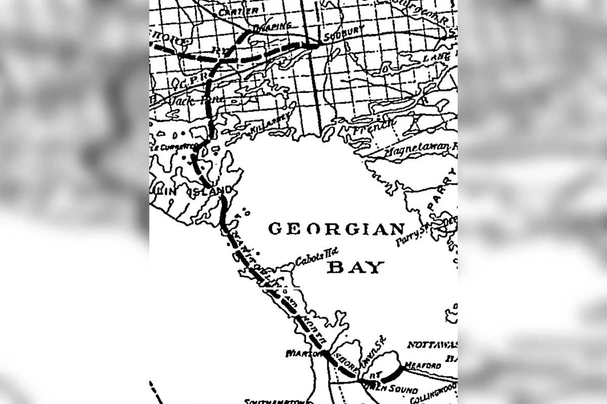
A publication from 1901 shows a potential rail route for the Manitoulin and North Shore Railway which crosses Fitzwilliam Island to points south.
***
One early proposal to close the Georgian Bay gap was tied to the Manitoulin and North Shore Railway – the same railway that built the Little Current Swing Bridge, which remains Manitoulin’s only road link to the mainland.
Although the railway only reached Little Current, the company wanted to extend the line right to Manitoulin Island’s south shore. From there, a railway car ferry would bring trains across to the Bruce Peninsula.
But the railway planners wanted as short a ferry trip as possible, even shorter than the current route, starting at the ferry dock South Baymouth. A 1901 map shows the proposed railway cutting across to the southern tip of Wiikwemkoong, then over a bridge or causeway to Fitzwilliam Island.
Launching at Fitzwilliam Island instead of South Baymouth would cut off nearly half of the distance of the current ferry route.
Fast-forward to 1964 and the idea had evolved to a permanent link all the way across the bay, not just to Fitzwilliam Island. Rather than a railway, the concept had shifted to a road that would connect Manitoulin and Tobermory year-round.
There was at least some serious thought put into this approach. In a 1964 article in The Wiarton Echo newspaper, the person encouraging the scheme was the head of regional development at the Ontario Department of Economics and Development (the modern-day Ministry of Economic Development, Job Creation and Trade).
The official predicted that, by the year 2020, there would be a “monumental impoundment structure” carrying a highway on a causeway, then splitting into two “super-highways” down the Bruce Peninsula and into southern Ontario.
As yet, none of those visions has ever come to pass and that is unlikely to change. In fact, later that same decade, government officials dismissed both the ideas of a causeway and a hovercraft service as unfeasible replacements for the ferry.
Still, the idea of a second road off of Manitoulin became a pet project for some Islanders.
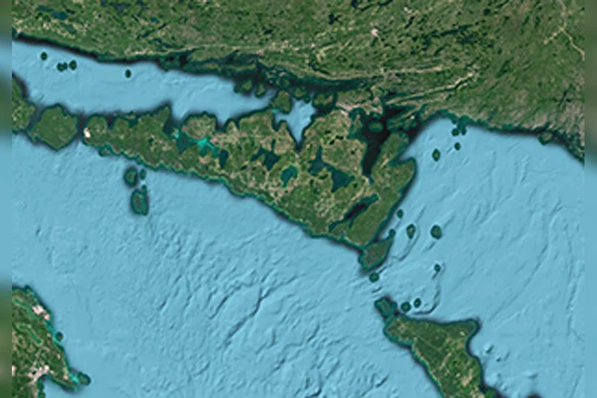
A satellite image of the crossing from Manitoulin south to Tobermory.
***
In the late 1980s, some members of the Manitowaning Board of Trade got behind the idea of a road to the Bruce.
Marg Hague remembers a well-attended public meeting around that time, to discuss the idea of such a crossing. She was the manager of the LaCloche-Manitoulin Business Assistance Corporation from 1988 to 2004.
“Some people thought it would bring in too many people; the old business of, ‘we like it the way it is,’” said Ms. Hague.
But there were legitimate concerns about the Tobermory connection at the time. The ferry demand was far higher than the existing boat could handle, leading to traffic delays, canceled trips and frustrated travelers.
Those pressures would be later eased by adding a second ferry, the Nindawayma. It only served for three years, from 1989 to 1992, before declining traffic and mechanical issues made it redundant.
A 1987 article in the Toronto Star featured some of the Manitowaning residents who championed the causeway idea. They included Board of Trade members Clyde VanZant and David Ham (Mr. Ham would later become mayor of Assiginack Township).
Mr. Ham took an interest in the causeway when he got a high-level view of the area – several hundred metres high, to be exact. He used to make several trips a day between Manitowaning and Tobermory in his plane and was intrigued by the underwater landscape below him.
“On real nice, calm days, you could look down and see the path that a bridge would follow. I’m not a bridge builder, but could see spots on bottom that, in my opinion, would support a bridge,” he said.
A look at navigational charts can help to explain what he saw from above. Between South Baymouth and Tobermory is a long chain of small islands and shoals. The water depth varies, but in many spots, it’s less than 20 metres deep.
In fact, there was once a bridge in this very area. Not a manmade one, but a land bridge along the Niagara Escarpment.
According to Parks Canada, the former land bridge existed thousands of years ago, before the Egyptian pyramids were even built. There was even a massive waterfall between what’s now Tobermory and Flowerpot Island, where a river emptied Lake Huron into the basin that became Georgian Bay.
But that shallow path doesn’t necessarily mean a road bridge would make sense in this location.
According to provincial data, average daily traffic counts on Highway 6, between the Bruce and Manitoulin, are about a third of the traffic on Highway 69/400. The massive Confederation Bridge to Prince Edward Island also carries nearly three times more traffic than Highway 6.
Ontario’s Ministry of Transportation said it has never conducted a feasibility study on a fixed road link between Manitoulin Island and the Bruce Peninsula.
***
Even if a future engineering study were to show that it was possible to build a road between Manitoulin Island and the Bruce Peninsula, there would be several other challenges to address.
To save costs, builders would likely try to stay on land for as long as possible. This might involve skirting along the bottom of Manitoulin Island, then crossing to Fitzwilliam Island before reaching the open water.
The southernmost parts of Manitoulin, across the mouth of South Bay, are all part of Wiikwemkoong Unceded Territory. There may be sites of cultural significance along the route and any construction proposals would have to meet with the community’s approval. This bridge would also have to cut across the lake, which could impact traditional harvesting and travel practices.
The Wiikwemkoong routing, if it could be approved, might be devastating for the community of South Baymouth, which currently receives all traffic coming off the ferry. Gary Brown, who co-owns Carl’s Trading Post in that town, said that’s a real concern.
“We cater mainly to the ferry but we do have a certain amount of business from the community here. I think it would have a slowing-down effect in the summertime on our town,” he said.
“It would probably make us more like the Muskokas, where you can get here in a few hours from Toronto,” said Mr. Brown. “I imagine a lot more people would come to Manitoulin.”
On the Tobermory side, there is a different issue – Fathom Five National Marine Park. The park covers more than 100 square kilometres between Tobermory Harbour and Cove Island, including Flowerpot Island and Bear’s Rump Island.
Parks Canada manages this zone and stewards it carefully to protect the landforms, plant and animal life and the numerous shipwrecks in the area.
Development is not necessarily prohibited in the area, but all proposals must be carefully planned to minimize the impacts on the sensitive ecosystem. Parks Canada did not have a spokesperson available for an interview in this story.
***
A more existential question remains: What would become of the character of towns like Tobermory and South Baymouth, if they are reduced to through-points on a road to the south, or bypassed altogether?
Both communities rely on the traffic that comes with the Chi-Cheemaun ferry. Drivers are expected to be at the dock an hour before departure, giving them ample time to stroll around the community, visit local businesses and take along souvenirs – either wrapped up as gifts, or stowed in their bellies.
They’re each at the very end of Highway 6 and have a certain slower-paced charm that draws in visitors from near and far.
“Tobermory has become a destination, much more than a way station,” said John Francis, the long-time publisher of The Peninsula Press newspaper in Tobermory.
He cited a survey by the local chamber of commerce that found the average visitor to Tobermory stays for about a week, meaning few visitors spend the night just to grab the morning ferry.
“The damage, I think, would be more physical than cultural,” he said, adding that the causeway idea seemed much more important on Manitoulin than on the Bruce Peninsula. “If that project went through, Tobermory would be in the shade of the on-ramp.”
Eric Stillwaugh co-owns the Huron Lodge Motel in South Baymouth, which has been in his family for generations. He also spent a few years working as a dockhand for the ferry, several decades ago.
He said that, aside from the huge costs of such a bridge, it may change travellers’ relationships with Manitoulin.
“I think you’d have more people going straight through, rather than vacationing and staying here. I think you’d see a lot of businesses shut down all over Manitoulin Island,” he said.
But it could also go the other way. Manitoulin Island remains a bit beyond the reach of Toronto-based daytrippers, but a causeway would put it within a four-hour drive from the heart of the city.
That could draw more people in, leading to overcrowding, traffic and strain on the seasonal businesses that have adapted to a certain level of demand.
The 1964 news report that predicted a great causeway by 2020 also warned of the threat of overcrowding.
“Just 40 years ahead of you is the greatest incoming stampede of recreation consumers ever known to man. They can make your region rich, powerful and important.
“They can also debase, terrorize and destroy it, drive yourselves and your children before them in a fierce search for a place of your own to survive, let alone relax,” was a quote from Ontario’s head of regional development.
The balance between progress and preservation can be delicate at the best of times and especially so in a place like Manitoulin Island. And while a road to Tobermory is likely not in this island’s future, it may still be useful as an exercise in dreaming big and imagining the future of this region, for better or for worse.
How will you make your way to Manitoulin Island this season?